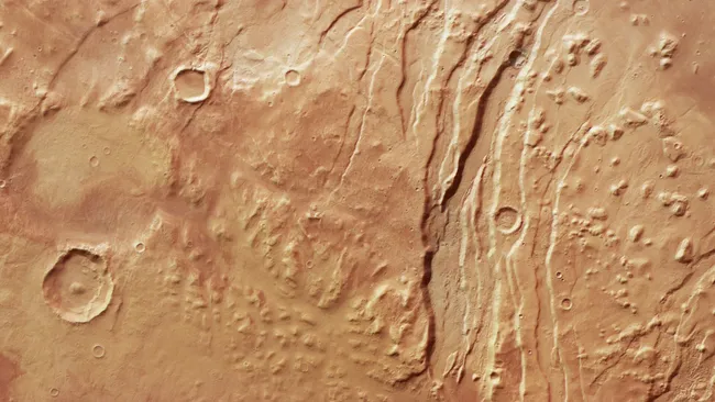
For over 20 years, the European Space Agency’s (ESA) Mars Express orbiter has captured breathtaking views of the Red Planet. Among its most intriguing subjects is Acheron Fossae, a region filled with dramatic geological formations. A newly released high-resolution image focuses on the western edge, offering an unprecedented view of this Martian wonder.
Acheron Fossae is defined by fault-like channels, or fossae, slicing through the terrain. These form raised ridges called horsts and sunken valleys known as grabens, resembling immense scars across the surface. ESA scientists believe the fossae formed around 3.7 billion years ago, during Mars’ most geologically active era, when molten rock forced the crust apart.
The story didn’t end there. Over millennia, massive rock glaciers — composed of rock, sand, and ice — sculpted the land further. To the right of the fossae in the image, their slow movement created rounded hills, or knobs, and flat-topped mesas.
The photo also reveals contrasting plains: lowlands on the right, highlands on the left. Zooming out would reveal that the highlands stretch toward Olympus Mons, the tallest volcano in the solar system at 13.6 miles (22 km) high, located about 746 miles (1,200 km) west of Acheron Fossae.
Adding to the region’s complexity are numerous impact craters in varying states of erosion, evidence of Mars’ ongoing bombardment by space debris. ESA confirmed Mars Express will operate through at least the end of 2026, allowing more time to uncover the Red Planet’s geological secrets.